ABOUT MANGLUMUKH VILLAGE
Manglumkh Village - History - Village Establishment - Founder
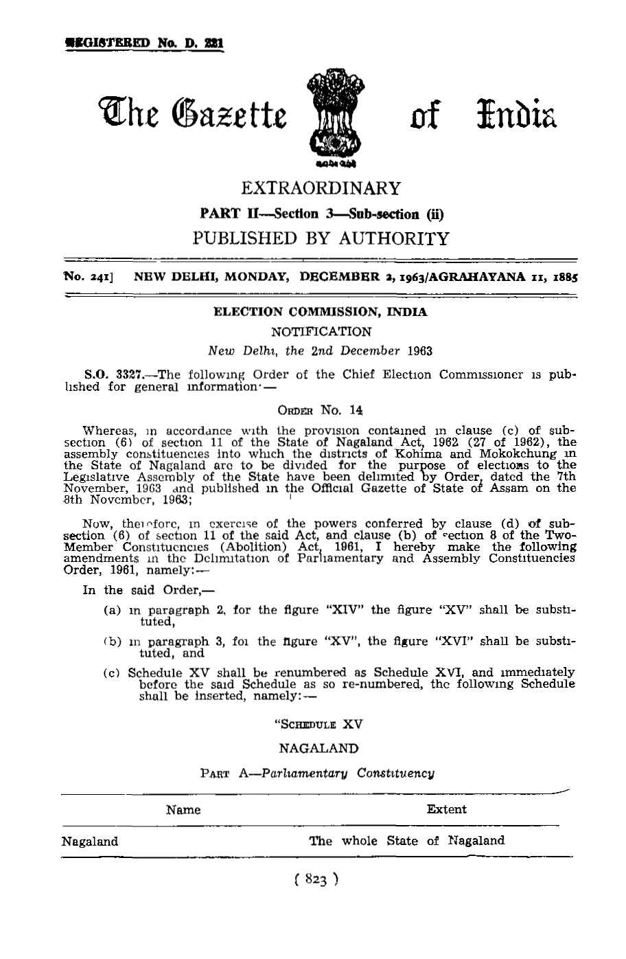
Manglumukh Village is Located in Dimapur District of Nagaland State Established in 1907.
- Anjiram Village, Now known as Manglumukh Village or also called Manglamukh Village was Established in 1907
By Late. Anjiram Daolagajao.
During that time Mr. A.N Davis was the Deputy Commissioner of the Naga Hills then.
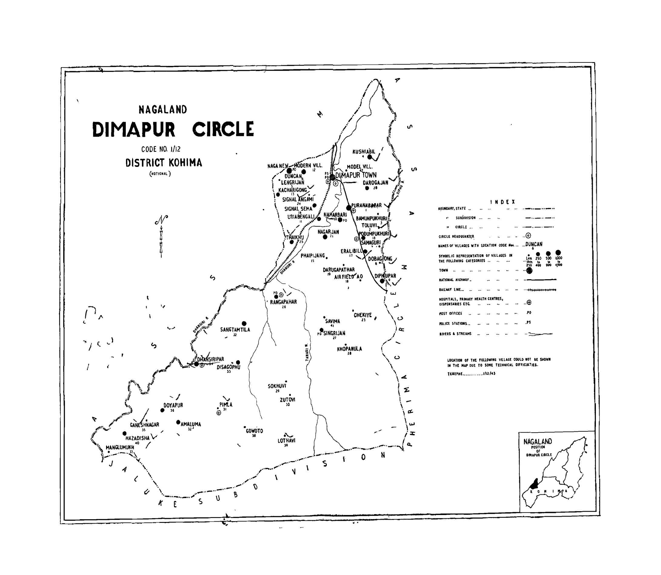
Village is Surrounded by Karbi-Along District of Assam in the
West and by Peren District in the West-East of Nagaland.
- Village Founded By Late Anjiram Daolagajao In Late 1907.
Manglumukh Village also known by Nayungwari Nolai (Village) in Dimasa Language meaning River of Large Fish or also call Manglamukh or Manglamakh Village.
- Manglamukh or Manglumukh is a medium size village located in Dhansiripar Circle of Dimapur district, Nagaland with total 59 families residing.
The Manglamukh or Manglumukh Village has population of 296 of which 141 are males while 155 are females as per Population Census 2011.
-
In Manglamukh or Manglumukh Village population of children with age 0-6 is 49 which makes up 16.55 % of total population of village. Average Sex Ratio of Manglamukh or Manglumukh Village is 1099 which is higher than Nagaland state average of 931.
Child Sex Ratio for the Manglamukh or Manglumukh as per census is 1450, higher than Nagaland average of 943.
- Manglamukh or Manglumukh Village has lower literacy rate compared to Nagaland. In 2011, literacy rate of Manglumukh village was 68.02 % compared to 79.55 % of Nagaland. In Manglamukh or Manglumukh Male literacy stands at 78.51 % while female literacy rate was 57.94 %.
- As per constitution of India and Panchyati Raaj Act, Manglamukh or Manglumukh Village is administrated by Sarpanch (Head of Village) who is elected representative of village.
- Dhansiri River flows through the Village of Manglumukh.
- Manglumukh Village Tribe / Community - Dimasa Kachari
- Manglumukh Village Road/Map/Location/Area - Hazadisa Road Dimapur Nagaland Sub Division Dhansiripar.
- Manglumukh Village Pin Code - 797112
- Manglumukh Village History
Manglamukh or Manglumukh Village Data Census Population.
Manglamukh or Manglumukh Village Data As Per Census 2011.
| Particulars |
Total |
Male |
Female |
| Total No. of Houses |
59 |
- |
- |
| Population |
296 |
141 |
155 |
| Child (0-6) |
49 |
20 |
29 |
| Schedule Caste |
0 |
0 |
0 |
| Schedule Tribe |
278 |
130 |
148 |
| Literacy Rate |
68.02 % |
78.51 % |
57.94 % |
| Total Workers |
105 |
83 |
22 |
| Main Worker |
103 |
- |
- |
| Marginal Worker |
2 |
2 |
0 |
Points on Manglumukh Village/Anjiram village
| Village Name |
Anjiram Village (Now Manglumukh Village) |
| Founder |
Anjiram Daolagajao (Daulagajao) 1907 |
| Established Year |
1907 |
| No. of Houses in Manglumukh in 1921 |
7 houses in 1921 |
| State |
Nagaland |
| District |
Dimapur |
| Country |
India |
- About Dimapur District.
Dimapur is the largest city in Nagaland, India. In the Middle Ages, it was the capital of the
Dimasa Kachari rulers. In the heart of the town there is an old historical object of the Dimasa
Kachari Kingdom which speaks about the once wealthy era. Dimapur is the 115 th most
crowded city in the country. It is located at 25°54′45″N 93°44′30″E and is surrounded by Kohima
district on the south and east, Karbi Anglong district of Assam on the west, the Karbi Anglong
and stretch of Golaghat District of Assam, in the west and the north. Dimapur city also has the
only functional airport in the state. Dimapur contains ruins of temples, reservoirs and other
monuments of which the most prominent are their monumental structures. The monoliths
represent the complex customs of the sect of fertility. The wonderfully executed entrances to
these monuments is in perfect condition even now. Blocks of stone and brick pieces with various
patterns that lie scattered, still disclose the creativity. The North East Zone Cultural Center,
which is about 3 km from the Dimapur railway station has a small well-preserved museum
showcasing the cultural heritage of the Northeast. Market of Dimapur city are famous for
imported goods from China , Burma and Thailand. On the outskirts lies Chumukedima from
where one can take a short trek up the hill to the Naga Tourist Village and the Patkai Triple Falls.
The North East- Zonal Cultural Center, the center for all cultural activities, is a kilometre away
from Dimapur Airport.
The Nagaland Industrial Growth Centre is located at Ganeshnagar of Dhansiripar Sub-Division,
where most of the Dimasa Kachari lived — an area consisting of seven Dimasa Villages
(Dhansiripar, Disaguphu, Amaluma, Doyapur, Ganeshnagar, Hazadisa and Manglumukh).
- Dimapur District.
During World War II, Dimapur was the centre of action between British India and Imperial Japan.
It was the staging post for the Allied offensive. The Japanese could reach Kohima where a siege was laid.
Allied reinforcement came through Dimapur by rail and road for the push against the Japanese.
An airport at Dimapur was also in use for supplies to the allied forces in Burma.
The battle for Kohima about 77 km from Dimapur is considered the turning point for the Japanese retreat from South East Asia.
- Kachari Ruins Rajbari Dimapur.
Kachari Ruins or The Dimasa Kachari Ruins is located in the town of Dimapur in Nagaland.
The ruins are a series of mushroom domed pillars that were created by the Dimasa Kachari Kingdoms that ruled before the Ahom invasion during the 13th century.
The purpose and origin of the pillars are mysterious; few of the pillars stand in full glory while others are crumbled down.
It is also believed that a game similar to that of chess was played here with the mushroom shaped dooms.
It is a glory of the North East and the tourism department of Nagaland.
Although it is left in ruins after centuries of abandonment, after facing conflict with the Ahom King in 18th century and with
the settlement of township occupying almost half of its former glorious fortress, is still a national heritage site.
It signifies great historical importance for the region of North-East. It also gives great value to the state of Nagaland.
- Dimasa Society.
The Dimasa society is tradition bound and guided by customs.
A very outstanding feature of the Dimasa culture and an important aspect of their social relation is the existence of male and female clan.
The male clan is called Sengphong and the female clan is known as Jadi or Julu.
Hence a Dimasa bears allegiance to both male and female clan. There are forty male clan and forty-two female clan.
Whether in marriage, religious practices, or in rituals connected with the death, the clans have a significant role to play.
Hence the clan plays an important part while fixing the marriage of a boy or a girl. If they belong to the same male or female clan,
they are not allowed to be married. Affiliation to one’s own respective clan is quite strong among the Dimasa. That clan ties are
important among the Dimasa can be understood from instances when the entire members of the clan take offence if any member of the clan
is offended by someone from outside their clan.
- CREATED BY HAMSRINGDAO BHATARI.
 Manglumukh Village Dimapur
.jpg "Manglumukh Village Photos")
.jpg "Manglumukh Village Photos")
.jpg "Manglumukh Village Photos")


.jpg "Manglumukh Village Photos")

.jpg "Manglumukh Village Photos")
.jpg "Manglumukh Village Photos")
.jpg "Manglumukh Village Photos")
.jpg "Manglumukh Village Photos")
.jpg "Manglumukh Village Photos")
.jpg "Manglumukh Village Photos")
.jpg "Manglumukh Village Photos")
.jpg "Manglumukh Village Photos")
.jpg "Manglumukh Village Photos")
.jpg "Manglumukh Village Photos")
.jpg "Manglumukh Village Photos")

 Manglumukh Students' Union Nagaland

